19 Comments on "All Toll Roads Lead to Staten Island"
janne
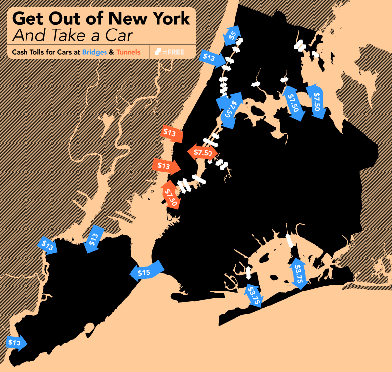
The reverse coloring, i.e. black for land masses and peach for water, makes it very difficult to recognize the landscape. I would suggest reversing the colors.
Lou
The Verrazano Narrows Bridge is $15. Your researchers did a poor job.
jackson
it only took 10 minutes to figure out what I was looking at, and I know the area well.
makes you wonder where all that money is going?
q-ball
the Ad Choices on
this page are as novel as
the graphic design
jeff
The toll for the Nenry Hudson Bridge is $3.75 each way, not $5. Actually less with EZ-Pass.
jeff
Correction: EZ-Pass toll on Henry Hudson is $2.44. Cash is not accepted. If you have no EZ-Pass, a photo is taken of your plate, and a bill for $5 is sent to your home.
The bridges of San Francisco Bay have tolls toward the City and not away. I used to sometimes go clockwise around the south end of the Bay for this reason.
Patrick
Round-trip from D.C. to CT on I-95 and NJT costs about $65.00 in tolls, assuming you use the GW Bridge.
Verrazano-Narrows Bridge (Roundtrip toll collected entering Staten Island only)
E-ZPass**
$10.66
Cash
$15.00
Henry Hudson Bridge (non-stop, cashless operation)
E-ZPass**
$2.44
Toll by Mail
$5.00
Cross Bay and Marine Parkway Bridges
E-ZPass**
$2.00
Cash
$3.75
Token*** $2.50
outfitter
If the stated purpose is to show how to get out of NY by car why show the inbound toll for the GWB and not show that their is no toll outbound? Indeed it would be more useful to show how to leave NY toll free by emphasizing and labeling the white arrows and minimizing the blue.
Susan Robertson
Fire your graphic designer. This map is incomprehensible even to people who know the area. Fire your researcher/fact checker. The information is crazily erratic. Who pays for this??
Tietrack
You have to be low information not to understand the map if your acquainted with NYC. I’ve been away 45 years and immediately recognized the areas on the map.
Contrary to other comments, I didn’t see any problems with the graphic design of this map. The colors are fine.
@outfitter – It’s not rocket science: Bridges/tunnels with two-way tolls have two-way arrows. If an arrow is pointing one way, travel in the opposite direction is free. Since the GWB arrow only points in, you know that the trip out is free. But if you live in NYC and you leave, you’ll eventually be returning, right? So it’s helpful to people to know how much they’ll have to pay to get back in. Having separate arrows for each direction would only make the map look more cluttered, and it might give the impression that there are two separate bridges.
@Susan – What’s wrong with the facts on this map? As Dan noted two comments above yours, the tolls are correct for someone paying cash. The designer probably figured it’s better go with the highest possible price (as people who don’t leave NYC by car often likely don’t have EZPass), rather than cluttering up the map with details about EZPass, tokens, Staten Island resident commuter rates, etc.
I don’t live in NYC, but I’ve been there many times, and the map makes perfect sense to me. I’m glad Tietrack had a similar impression.
Seems like many people “visualize” NYC by the look of the official subway map, but fail to realize the subway map is not 100% geographically accurate. Although the general layout is correct (Manhattan is to the west, while Queens is to the east, and Brooklyn to the southeast), the subway map is primarily designed to clearly show where the lines and stations are… certain things have been stretched, compressed or otherwise altered simply for the convenience of the map designers to fit certain words in certain places.
Fred
I got it. Took a minute, but that’s good! Like Luminosity… brain-games. Not exactly a PRETTY map, but functional and OK. In any case, the prices are ridiculously high all around. I remember when they only collected tolls to (supposedly) pay for the construction of the highway… or was that just an Urban Myth… or simply a big lie?
Nomen Nescio
This is how the dwarf mayor of New York practices taxation without representation for the 3.5 million people of Long Island who only want to drive through ‘his’ city:
And as a side note, as originally promised when the bridges and tunnels were constructed, the tolls were only to exist until they were paid off, and then tolls would be reduced to levels equal to the cost of maintenance.
Instead, there have been no reductions, only increases, and 80% of revenue goes to subsidize buses and subways in the City.
And…. to fund the enormous salaries and benefits of those who run the Port Authority which is in charge of the bridges and tunnels.
That note about black land and peach water gets at something bigger than design taste: you were protecting legibility. When a map makes a familiar place feel unrecognizable, the whole idea starts slipping away.
The reverse coloring, i.e. black for land masses and peach for water, makes it very difficult to recognize the landscape. I would suggest reversing the colors.
The Verrazano Narrows Bridge is $15. Your researchers did a poor job.
it only took 10 minutes to figure out what I was looking at, and I know the area well.
makes you wonder where all that money is going?
the Ad Choices on
this page are as novel as
the graphic design
The toll for the Nenry Hudson Bridge is $3.75 each way, not $5. Actually less with EZ-Pass.
Correction: EZ-Pass toll on Henry Hudson is $2.44. Cash is not accepted. If you have no EZ-Pass, a photo is taken of your plate, and a bill for $5 is sent to your home.
The bridges of San Francisco Bay have tolls toward the City and not away. I used to sometimes go clockwise around the south end of the Bay for this reason.
Round-trip from D.C. to CT on I-95 and NJT costs about $65.00 in tolls, assuming you use the GW Bridge.
CARS:
Bronx-Whitestone, Throgs Neck, & RFK Bridges; Hugh L Carey1 & Queens Midtown Tunnels
E-ZPass**
$5.33
Cash
$7.50
Verrazano-Narrows Bridge (Roundtrip toll collected entering Staten Island only)
E-ZPass**
$10.66
Cash
$15.00
Henry Hudson Bridge (non-stop, cashless operation)
E-ZPass**
$2.44
Toll by Mail
$5.00
Cross Bay and Marine Parkway Bridges
E-ZPass**
$2.00
Cash
$3.75
Token*** $2.50
If the stated purpose is to show how to get out of NY by car why show the inbound toll for the GWB and not show that their is no toll outbound? Indeed it would be more useful to show how to leave NY toll free by emphasizing and labeling the white arrows and minimizing the blue.
Fire your graphic designer. This map is incomprehensible even to people who know the area. Fire your researcher/fact checker. The information is crazily erratic. Who pays for this??
You have to be low information not to understand the map if your acquainted with NYC. I’ve been away 45 years and immediately recognized the areas on the map.
Contrary to other comments, I didn’t see any problems with the graphic design of this map. The colors are fine.
@outfitter – It’s not rocket science: Bridges/tunnels with two-way tolls have two-way arrows. If an arrow is pointing one way, travel in the opposite direction is free. Since the GWB arrow only points in, you know that the trip out is free. But if you live in NYC and you leave, you’ll eventually be returning, right? So it’s helpful to people to know how much they’ll have to pay to get back in. Having separate arrows for each direction would only make the map look more cluttered, and it might give the impression that there are two separate bridges.
@Susan – What’s wrong with the facts on this map? As Dan noted two comments above yours, the tolls are correct for someone paying cash. The designer probably figured it’s better go with the highest possible price (as people who don’t leave NYC by car often likely don’t have EZPass), rather than cluttering up the map with details about EZPass, tokens, Staten Island resident commuter rates, etc.
I don’t live in NYC, but I’ve been there many times, and the map makes perfect sense to me. I’m glad Tietrack had a similar impression.
Seems like many people “visualize” NYC by the look of the official subway map, but fail to realize the subway map is not 100% geographically accurate. Although the general layout is correct (Manhattan is to the west, while Queens is to the east, and Brooklyn to the southeast), the subway map is primarily designed to clearly show where the lines and stations are… certain things have been stretched, compressed or otherwise altered simply for the convenience of the map designers to fit certain words in certain places.
I got it. Took a minute, but that’s good! Like Luminosity… brain-games. Not exactly a PRETTY map, but functional and OK. In any case, the prices are ridiculously high all around. I remember when they only collected tolls to (supposedly) pay for the construction of the highway… or was that just an Urban Myth… or simply a big lie?
This is how the dwarf mayor of New York practices taxation without representation for the 3.5 million people of Long Island who only want to drive through ‘his’ city:
And as a side note, as originally promised when the bridges and tunnels were constructed, the tolls were only to exist until they were paid off, and then tolls would be reduced to levels equal to the cost of maintenance.
Instead, there have been no reductions, only increases, and 80% of revenue goes to subsidize buses and subways in the City.
And…. to fund the enormous salaries and benefits of those who run the Port Authority which is in charge of the bridges and tunnels.
Ain’t that special.
Nomen Nescio
We’re trapped.
With so many free bridges across the East and Harlem Rivers, why pay toll?
That note about black land and peach water gets at something bigger than design taste: you were protecting legibility. When a map makes a familiar place feel unrecognizable, the whole idea starts slipping away.
Interesting take on toll roads! I’ve been looking for a tomodachi life personality chart to help with my game.
click